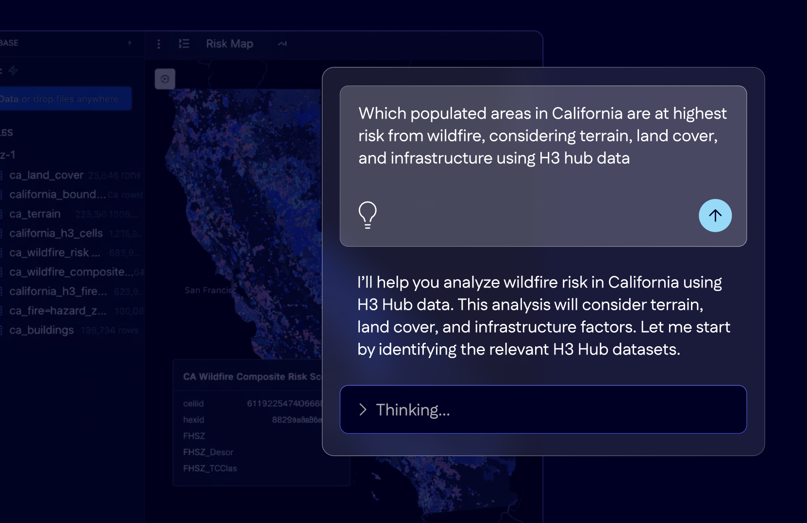
Introducing FSQ Spatial Agent: Your Geospatial AI Analyst
https://foursquare.com/resources/blog/ad-tech/introducing-fsq-spatial-agent-your-geospatial-ai-analyst/
#AI #Geospatial #AdTech
#geospatial
32 posts · Last used 21d
Boosted by @fedicat@pc.cafe
Mapstodon.space is a Mastodon server for cartography & geospatial people including professionals and enthusiasts. Ask questions, share your maps, chat around, enjoy the emojis!
https://mapstodon.space
You can find out more at https://mapstodon.space/about or contact the server admin @jeremy@mapstodon.space#FeaturedServer #Maps #Geospatial #Cartography #Mapping #Geography #GIS #Mastodon #Fediverse #FreeFediverse

QGIS-Tip: New Plugin „Ribbon Toolbar“ https://geoobserver.de/2026/09/25/qgis-tipp-neues-plugin-ribbon-toolbar/ #qgis #plugin #switch2qgis #gistribe #gischat #fossgis #foss4g #OSGeo #spatial #geospatial #opensource #gis #geo #geoObserver pls RT
Boosted by @fedicat@pc.cafe
Datasci.social is a Mastodon server for researchers & practitioners in human-centric data science, broadly defined. For example human-centric network science, social data science, computational social science, geospatial data science etc.
https://datasci.social
You can find out more at https://datasci.social/about or contact the admin account @mszll@datasci.social#FeaturedServer #DataScience #NetworkScience #Geospatial #Mastodon #Fediverse #FreeFediverse
⚠️ Why standard GIS routing (D8, Sink Fill) fails in complex mining regions: 300m open pits become fake "lakes", and underground river tunnels are completely ignored.
To map surface drainage across central Kryvyi Rih, I built a custom DEM hydro-conditioning pipeline:
🔹 Selective sink filtering (true pits vs DEM noise)
🔹 Subsurface conduit burn-in (diversion tunnels)
🔹 Closed micro-catchment delineation
Crucial for geochemical transport & geotechnical risks.
🛠️ #RStats (#terra, #Rsagacmd), #QGIS, #SAGAGIS
#GIS #Hydrology #HydroEnforcement #FOSSGIS #Mining #Geospatial #KryvyiRih #DigitalTerrainAnalysis
DeepMind & Google Research: Googles neues KI-Wettermodell / Google’s new AI weather model https://geoobserver.de/2026/07/31/deepmind-google-research-googles-neues-ki-wettermodell/ via @PeterWBattaglia #waether #deepmind #google #ai #gistribe #gischat #fossgis #foss4g #OSGeo #spatial #geospatial #gis #geo #geoObserver pls RT
WTAF!
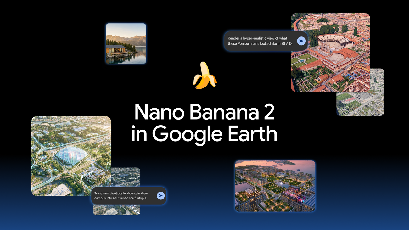
They've essentially taken satellite imagery, one of the world's most recognisable sources of geographic ground truth, and attached an hallucination engine to it.
'Reimagine the world with Nano Banana in Google Earth'
#technology #ai #geospatial #science #osint #disinformation
🚨 15 days left! 🚨
The Call for Talks and Early Bird Tickets for FOSS4G:UK 2026 are closing at the end of this month. If you haven’t already, now’s the time to submit your talk and grab your discounted ticket before it’s too late!
We’re looking forward to welcoming everyone to Leeds this October: uk.osgeo.org/foss4guk2026/
#FOSS4GUK #FOSS4G #OSGeoUK #GIS #Geospatial #Leeds #OSGeo #GeoCommunity #UKEvent
We’re excited to announce Ana Basiri as a Keynote Speaker for FOSS4G:UK 2026! 🎉
Ana Basiri is Professor and Chair of #Geospatial #Data Science at the University of #Glasgow, Director of the Centre for Data Science and AI, and a #UKRI Future Leaders Fellow. She leads an interdisciplinary team working on developing theoretical and applied solutions to the challenges posed by new forms of data, particularly missingness, bias, and data quality issues. Her work is founded on the principle that ...
Replying to
Presenting at the event is the best way to connect with fellow professionals, don't miss your chance, submit a talk (lightening)/workshop before 31st July and get your early bird discount.
Join us at the FOSS4G:UK in Leeds on October 12 & 13: https://uk.osgeo.org/foss4guk2026/
#FOSS4GUK #FOSS4G #OSGeoUK #GIS #Geospatial #Leeds #OSGeo #GeoCommunity #UKEvent
Update „Geo Hound“: 2.0 https://geoobserver.de/2026/07/30/update-fuer-geo-hound-neue-version-2-0/ via @MapScaping #gistribe #gischat #fossgis #foss4g #OSGeo #spatial #geospatial #mapping #qgis #switch2qgis #gis #geo #geoObserver pls RT
Learn why ground-truthing is important in this presentation by Rob Savoye at #SOTMUS2026:
🔗 https://youtu.be/LYNturLYIb0?si=60sF2OaxQF_tq8y0
🦩
#OpenStreetMap #groundtruthing #opendata #geo #geospatial
Why Ground-Truthing is Important ~ Rob Savoye
ArcGIS Flight Simulator: Cédric Despierre Corporon built a browser-based #FlightSimulator on the #ArcGIS Maps SDK for #JavaScript, streaming Swiss terrain and buildings from #swisstopo alongside global #OSM data. While obviously not a full flight sim, this is a genuinely...
https://spatialists.ch/posts/2026/07/27-arcgis-flight-simulator/ #GIS #GISchat #geospatial #SwissGIS
Mein Tool des Monats / My tool of the month: formatterorg https://geoobserver.de/2026/07/27/mein-tool-des-monats-formatterdotorg/ #gistribe #gischat #fossgis #foss4g #OSGeo #spatial #geospatial #geos #gis #geo #geoObserver pls RT
London "Geo" Meetup #5 is coming up!
We’re excited to share that we now have a venue for the #August #meetup: Birkbeck College, University of London
📅 12th August
🕕 6:00 PM onwards
📍 Birkbeck, London
This time, we’re also organizing a #QGIS #workshop as part of the #meetup — a great way to welcome #newcomers and get hands-on with #geospatial tools.
We’re still looking for #speakers for the #event, so if you have a #geo story, #project, or #idea to share, we’d love to hear from you.
Buchtipp: „Künstliche Intelligenz in Geodäsie und Geoinformatik“ / Book recommendation: ‘Artificial Intelligence in Geodesy and Geoinformatics’ https://geoobserver.de/2026/07/24/buchtipp-kuenstliche-intelligenz-in-geodaesie-und-geoinformatik/ #ai #ki #gistribe #gischat #fossgis #foss4g #OSGeo #spatial #geospatial #opensource #gis #geo #geoObserver pls RT
Good news to share in the OSM US July newsletter:
😎 Mappy Hour on July 22
😎 State of the Map US wrap-up and videos
😎 OpenHistoricalMap’s Fundraising Success
🔗 https://openstreetmap.app.neoncrm.com/np/viewEmail.jsp?linkId=687792#OpenStreetMap #OSM #opendata #geospatial #GIS #mapping #cartography #geo
Sentinel-2 Paint: Mit Satellitenbildern malen? / Painting with satellite images? https://geoobserver.de/2026/07/21/sentinel-2-paint-mit-satellitenbildern-malen/ #gistribe #gischat #fossgis #foss4g #OSGeo #spatial #geospatial #mapping #DataViz #gis #geo #geoObserver pls RT
Wo ist „Downtown“ in Deiner Stadt? / Where is ‘downtown’ in your town? https://geoobserver.de/2026/07/22/wo-ist-downtown-in-deiner-stadt/ #gistribe #gischat #fossgis #foss4g #OSGeo #spatial #geospatial #mapping #DataViz #gis #geo #geoObserver pls RT